
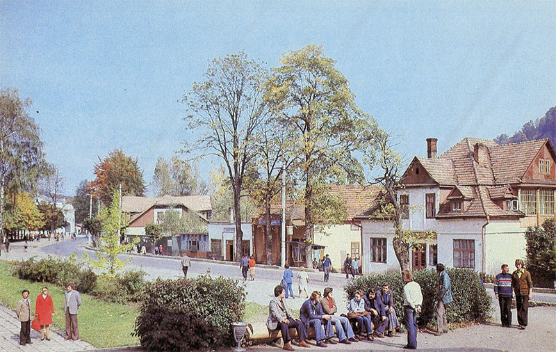
This 1990 art postcard depicts daily life on Lenin Street in the Carpathian resort town of Yaremcha (now Yaremche).
What is shown on the postcard
The photograph captures the pedestrian zone and the roadway of the street. In the left and central parts of the frame, pedestrians are walking, while in the right foreground, a group of people is resting on a wooden log bench near a green lawn. In the background, low-rise public and residential buildings with gabled tiled roofs are visible, surrounded by tall trees. A decorative arch can be seen in the distance on the far left.
Historical note
During the Soviet period, Lenin Street served as the main transportation and social artery of Yaremcha. The town was actively developed as a major Carpathian climatic resort, attracting tourists from across the USSR to its sanatoriums, holiday bases, and scenic natural sites.
Present day
Today, the street has been renamed Svobody (Freedom) Street. It remains the main avenue of the town, hosting the bulk of the tourist infrastructure, including hotels, restaurants, souvenir markets, and administrative buildings.
Location (map)
Address: Svobody Street, Yaremche, Ivano-Frankivsk Oblast, Ukraine
Coordinates: 48.451400, 24.551500
(Google Maps)
Coordinate source: Approximate coordinates of the central part of Svobody (former Lenina) Street.
Questions and answers
- What is the current name of the street shown on the postcard? The former Lenin Street in Yaremche is now named Svobody Street.
- What is depicted in the foreground? The foreground shows people resting on a rustic log bench and pedestrians walking past green lawns and low-rise buildings.
- What is the significance of this area in Yaremche? This is the central part of the town, historically acting as the primary public and tourist hub of the Carpathian resort.
See also
The «Old Postcards» archive includes other views of Yaremche from 1990.

Reviews
There are no reviews yet.