
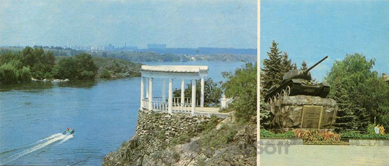
The 1984 postcard presents a view of the Dnieper River from Khortytsia Island in Zaporizhzhia, showcasing natural landscapes and significant memorial sites.
What is shown on the postcard
The left part of the postcard depicts a panorama of the Dnieper River, opening from an elevated point on Khortytsia Island. Central to this composition is a classical white rotunda-gazebo built on a stone foundation, offering a view of the river’s expanse and the opposite bank with distant urban development on the horizon. A small motorboat is seen moving on the river, leaving a wake.
The right part of the postcard features the Monument to Soviet Liberator Soldiers. The monument consists of a T-34 tank mounted on a pedestal made of large, unworked stones. A memorial plaque is situated beneath the tank. Coniferous and deciduous trees, as well as flowerbeds, surround the monument.
Historical note
Khortytsia Island, the largest river island on the Dnieper, holds rich historical significance as the cradle of Zaporozhian Cossacks. During the Soviet era, the island was actively developed as a cultural and historical preserve and a recreation area. The White Gazebo, located on a high rocky bank, is one of Khortytsia’s landmarks, offering picturesque views of the Dnieper. The Monument to Soviet Liberator Soldiers, erected in the 1970s, commemorates the events of World War II and the liberation of Zaporizhzhia from Nazi occupation.
Present day
Currently, Khortytsia Island retains its status as a National Reserve, attracting tourists with historical monuments, unique nature, and opportunities for outdoor activities. The White Gazebo remains a popular spot for Dnieper River views and photography. The T-34 tank monument continues to serve its memorial function as part of a complex of monuments dedicated to World War II events, although its perception and symbolic meaning may be re-evaluated in the modern Ukrainian context. The T-34 tank itself is one of the most mass-produced and famous combat vehicles of World War II.
Location (map)
Address: Khortytsia Island, Zaporizhzhia, Zaporizhzhia Oblast, Ukraine
Coordinates: 47.876700, 35.087700
(Google Maps)
Coordinate source: Coordinates of the White Gazebo on Khortytsia Island, offering a view of the Dnieper River..
Questions and answers
- What is depicted on the left part of the postcard? The left part of the postcard depicts a panorama of the Dnieper River, opening from an elevated point on Khortytsia Island, with a white rotunda-gazebo in the center.
- What monument is shown on the right part of the postcard? The right part of the postcard features the Monument to Soviet Liberator Soldiers in the form of a T-34 tank on a pedestal of unworked stones.
- What is the historical significance of Khortytsia Island? Khortytsia Island holds rich historical significance as the cradle of Zaporozhian Cossacks and was actively developed as a cultural and historical preserve during the Soviet era.
See also
The «Old Postcards» archive includes other views of Zaporizhzhia from 1984.

Reviews
There are no reviews yet.