

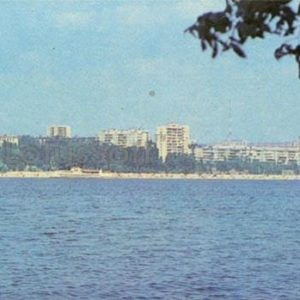
This 1984 postcard presents a panoramic view of the city of Zaporizhzhia from Khortytsia Island, encompassing the urban landscape of the Dnieper River’s Right Bank.
What is shown on the postcard
In the foreground of the postcard is the water surface of the Dnieper River. Beyond the river, on the Right Bank, urban development extends. On the left side of the image, multi-story residential buildings are visible. Closer to the center, behind an expanse of greenery, a large classical-style building with columns stands out, presumably the Regional State Administration building. To the right, other multi-story buildings are located, as well as a section of the bank resembling a beach. In the distance, on the horizon, the silhouettes of more distant city districts can be discerned.
Historical note
The development of Zaporizhzhia’s Right Bank actively occurred in the post-war period, especially from the 1950s, as the city expanded to meet the needs of industrialization and population growth. The building of the Zaporizhzhia Regional State Administration, constructed in the Stalinist Empire style, is one of the key architectural elements of the central part of the city and was completed by the mid-20th century.
In 1984, Zaporizhzhia was a major industrial and administrative center of the Ukrainian SSR, and Khortytsia already held the status of a state reserve, actively used for recreation and tourism. The urban panorama captured on the postcard reflects the typical appearance of a Soviet regional center of that era, with its monumental architecture and residential development.
Present day
Currently, the Right Bank of Zaporizhzhia continues to be a bustling urban area. The Regional State Administration building maintains its function. Khortytsia Island remains a National Reserve and a popular destination for tourism and recreation, playing an important role in the cultural and historical life of the region. The urban landscape has undergone changes, but the main architectural dominants visible on the postcard remain recognizable.
Location (map)
Address: Sobornyi Avenue, 164, Zaporizhzhia, Ukraine
Coordinates: 47.828600, 35.138800
(Google Maps)
Coordinate source: Coordinates of the Zaporizhzhia Regional State Administration (Sobornyi Ave, 164), a key building visible on the postcard..
Questions and answers
- From where was the photograph on the postcard taken? The photograph was taken from Khortytsia Island, looking towards the Right Bank of the Dnieper River in Zaporizhzhia.
- What significant building can be seen on the postcard? The postcard shows the building of the Zaporizhzhia Regional State Administration, built in a classical style with columns.
- What was the Right Bank of Zaporizhzhia like in 1984? In 1984, the Right Bank of Zaporizhzhia was an actively developing urban area with multi-story residential and administrative buildings, typical of a Soviet regional center.
See also
The «Old Postcards» archive includes other views of Zaporizhzhia from 1984.

Reviews
There are no reviews yet.