
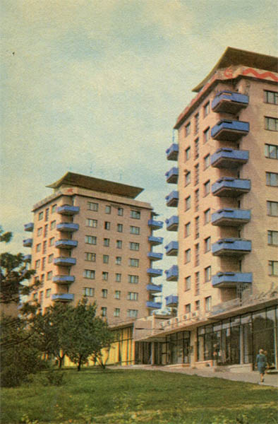
The 1969 postcard features high-rise residential buildings on what was then Transport Square in Zaporizhzhia, representing a vivid example of Soviet urban planning from the period.
What is shown on the postcard
In the foreground of the postcard are two multi-story residential buildings, characterized by the distinctive architecture of the 1960s. The facades of the buildings are light-colored, featuring rows of windows and bright blue cantilevered balconies. The building on the right has nine residential floors and one technical/decorative floor at the top, adorned with a wavy red element along the roof edge. The building on the left is similar in style but appears slightly shorter (eight residential floors). The ground floors of the buildings facing the square are glazed, indicating commercial or public spaces. A green lawn with young trees stretches out in front of the buildings. A human figure is visible on the sidewalk to the right.
Historical note
These buildings were constructed in the mid-1960s and became some of the first large-scale ‘high-rises’ in Zaporizhzhia. Their erection was part of the city’s active post-war development, aimed at providing housing for the growing population and creating a modern architectural image. Located on Transport Square (now Pryvokzalna Square), they formed an important urban ensemble near the Zaporizhzhia-1 railway station, acting as dominant features in this part of the city. The buildings’ architecture aligns with the functionalist trends of Soviet modernism, which rejected decorative excesses and focused on rationality and practicality.
Present day
The buildings depicted on the postcard still stand on Sobornyi Avenue (formerly Lenin Avenue) and are part of the modern development of Pryvokzalna Square. They continue to function as residential buildings, with their ground floors traditionally used for shops and offices. Although the facades may have undergone cosmetic renovations, the overall architectural appearance and structural features of the buildings have been preserved, remaining recognizable symbols of mid-20th century urban development in Zaporizhzhia.
Location (map)
Address: Sobornyi Avenue, 171A and 171B, Zaporizhzhia
Coordinates: 47.809150, 35.180230
(Google Maps)
Coordinate source: Coordinates identified by address: Sobornyi Avenue, 171A, Zaporizhzhia. The buildings are easily recognizable on modern maps..
Questions and answers
- When were these buildings constructed? These buildings were constructed in the mid-1960s as part of Zaporizhzhia’s active post-war development.
- What is the modern name of Transport Square? The modern name of Transport Square is Pryvokzalna Square.
- What is the architectural style of these buildings? The architecture of the buildings aligns with the functionalist trends of 1960s Soviet modernism.
See also
The «Old Postcards» archive includes other views of Zaporizhzhia from 1969.


Reviews
There are no reviews yet.