
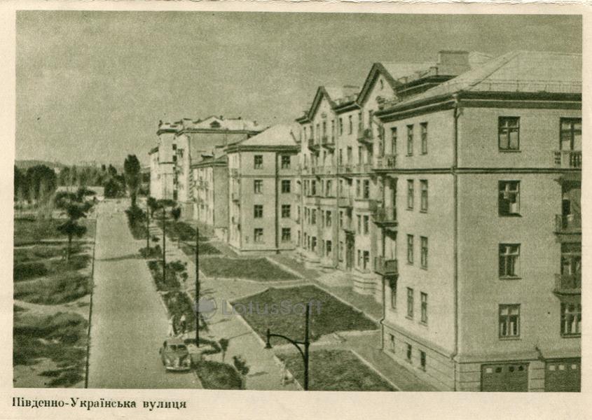
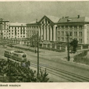
The “Yuzhno-Ukrainskaya Street” postcard from 1957 captures the architectural ensemble of post-war Zaporizhzhia. The image showcases the characteristic construction that shaped the city’s appearance in the mid-20th century.
What is shown on the postcard
The postcard displays a view of Yuzhno-Ukrainskaya Street in Zaporizhzhia. On the right side of the street, multi-story residential buildings in the Stalinist Empire style are visible, featuring characteristic decorative elements and balconies. The roadway is separated by green strips, with sidewalks, streetlights, and several trees also present. Residential buildings can also be seen along the left side of the street. A parked car is visible in the foreground on the right.
Historical note
Yuzhno-Ukrainskaya Street, named during the Soviet period, was part of a large-scale project for the restoration and development of Zaporizhzhia after the destruction of the Great Patriotic War. The city was almost completely destroyed, and its revival was carried out according to a master plan that envisioned the creation of wide avenues and stately residential quarters in the Stalinist Empire style. These buildings were intended to house industrial workers and intellectuals.
The street was one of the key thoroughfares of the new residential area, providing transport links and forming the aesthetic image of a “socialist city.” After Ukraine gained independence, as part of decommunization processes and renaming of toponyms, Yuzhno-Ukrainskaya Street was renamed Zaporizka Street.
Present day
Today, the former Yuzhno-Ukrainskaya Street, now Zaporizka Street, retains its historical appearance. The buildings depicted on the postcard continue to serve as residential properties. The street remains an important transport artery and a part of Zaporizhzhia’s central development, testifying to the urban planning approaches of the mid-20th century. Despite the decades that have passed, the architectural ensemble of the street remains largely recognizable, although it has undergone changes in details such as balcony glazing and facade conditions.
Location (map)
Address: Zaporizka Street, Zaporizhzhia, Ukraine
Coordinates: 47.830635, 35.187310
(Google Maps)
Coordinate source: Approximate coordinates for the section of Zaporizka Street (formerly Yuzhno-Ukrainskaya), Zaporizhzhia, where the buildings depicted on the postcard are located..
Questions and answers
- What is the modern name of Yuzhno-Ukrainskaya Street? The modern name of Yuzhno-Ukrainskaya Street in Zaporizhzhia is Zaporizka Street.
- In what architectural style are the buildings on the postcard designed? The buildings on the postcard are designed in the Stalinist Empire style, characteristic of post-war construction.
- Why was the street renamed? The street was renamed as part of decommunization processes and changes in toponyms after Ukraine gained independence.
See also
The «Old Postcards» archive includes other views of Zaporizhzhia from 1957.

Reviews
There are no reviews yet.