
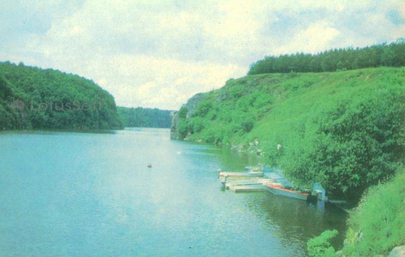
This 1979 Soviet collectible postcard presents a panoramic view of the Teteriv River canyon within the city limits of Zhytomyr.
What is shown on the postcard
The image captures a deep-water section of the Teteriv River, surrounded by steep rocky banks covered with dense green vegetation and trees. On the right side, a small wooden pier with moored rowing boats is visible near the shore. The winding riverbed stretches toward the horizon under a cloudy sky.
Historical note
The Teteriv River canyon in Zhytomyr is formed by Precambrian granite outcroppings. In 1965, the construction of the Zhytomyr reservoir dam raised the water level, altering the historical landscape by partially submerging the cliffs and creating a scenic deep-water zone within the city. The area has traditionally been used by locals for recreation, water tourism, and rowing practice.
Present day
Today, the Teteriv canyon remains a key natural recreational zone in Zhytomyr. The rocky shores, including famous geological monuments like ‘Chatsky’s Head’ and the ‘Four Brothers’ rocks, are protected natural sites and popular destinations for rock climbing and hiking.
Location (map)
Address: Teteriv River, Zhytomyr, Zhytomyr Oblast, Ukraine
Coordinates: 50.241500, 28.636800
(Google Maps)
Coordinate source: Coordinates of the Teteriv River canyon in Zhytomyr near Chatsky Head rock.
Questions and answers
- What engineering structure affected the river’s appearance? The river’s appearance changed after the construction of the Zhytomyr reservoir dam in 1965, which raised the water level.
- What is located near the right bank in the photo? A small wooden pier with moored rowing boats is visible near the right bank.
- What geological landmarks are located in this canyon? The canyon features famous rock formations protected as natural monuments, such as ‘Chatsky’s Head’ and ‘Four Brothers’.
See also
The «Old Postcards» archive includes other views of Zhytomyr from 1979.



Reviews
There are no reviews yet.