
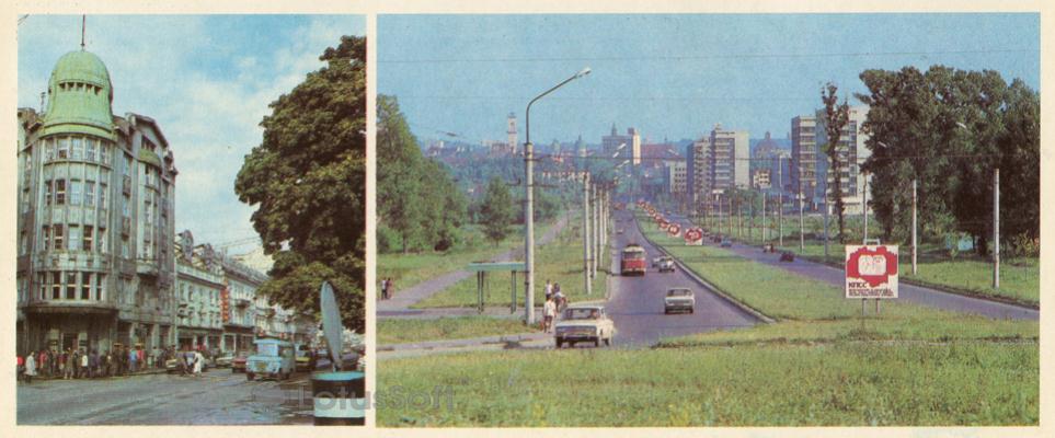
A double-view Soviet postcard from 1984, showcasing the contrast between the historic and modern architecture of Lviv: Lenin Avenue (now Svobody Avenue) and 700th Anniversary of Lviv Street (now Viacheslava Chornovola Avenue).
What is shown on the postcard
The left side of the postcard depicts Lenin Avenue featuring a prominent Art Nouveau corner building topped with a green dome. Pedestrians, parked Soviet cars, and a small van are visible near the building. The right side presents a panoramic view of the wide 700th Anniversary of Lviv Street with a multi-lane roadway, a central lawn divider, trolleybus lines, and sparse traffic. A Soviet propaganda sign with the abbreviation ‘KPSS’ is installed by the roadside. In the far background, the skyline of the historic city center, including the tower of Lviv Town Hall, is visible.
Historical note
Lenin Avenue (historically Hetmanska Ramparts) served as the main administrative and public artery of the city during the 19th and 20th centuries. The corner building (No. 11) was constructed in 1911–1912 for the Prague Credit Bank. The 700th Anniversary of Lviv Street was laid out in the Soviet era (late 1950s) as a new modernist thoroughfare connecting the city center with the northern residential districts. It was named in honor of the city’s anniversary celebrated in 1956.
Present day
Today, Lenin Avenue has been renamed Svobody Avenue, and the 700th Anniversary of Lviv Street is known as Viacheslava Chornovola Avenue. The historic Prague Bank building has preserved its architectural appearance and continues to house financial institutions. Chornovola Avenue has undergone significant redevelopment with new commercial high-rises, shopping centers, and modern residential complexes.
Location (map)
Address: 11 Svobody Avenue, Lviv, Lviv Oblast, Ukraine
Coordinates: 49.840100, 24.027400
(Google Maps)
Coordinate source: Coordinates identified by the former Prague Bank building (11 Svobody Avenue) on the left image.
Questions and answers
- Which streets are depicted on the postcard? The postcard shows Lenin Avenue (now Svobody Avenue) on the left image and the 700th Anniversary of Lviv Street (now Viacheslava Chornovola Avenue) on the right image.
- What is the domed building shown on the left? It is the former Prague Credit Bank building, constructed in 1911–1912, located at No. 11 Svobody Avenue.
- What landmark can be seen on the horizon of the right image? In the distance, along the perspective of the 700th Anniversary street, the tower of the Lviv Town Hall (Ratusha) on Rynok Square is visible on the horizon.
See also
The «Old Postcards» archive includes other views of Lviv from 1984.





Reviews
There are no reviews yet.